My Travel and History Blog, Focussing mostly on Roman and Mediaeval Times
29 Aug 2007
Let's Play - Romany Toys
Here are some Roman toys from the Saalburg Museum. There is a special exhibition for children where Roman life is explained in an easy to understand way; and the curators took care to find some extra goodies for the kids. Most of the material presented in the museum is from excavations in the Saalburg area, but the toys partly come from other diggings.
Since wooden and other organic artefacts have seldom been preserved, our knowledge about Roman toys is probably limited, since there will also have been wooden figures, rag dolls, and the like that haven't survived.

Toy soldier
The little guy was less bendable than his modern counterpart, but he had a removable spear in his hand, and he was painted as brightly as the star trooper that keeps him company. The shield is too small for a Roman foot soldier, though, and the hair style looks like a Suevi knot, so maybe he was a member of the enemy army, or an auxiliary. Read more »
Here are some Roman toys from the Saalburg Museum. There is a special exhibition for children where Roman life is explained in an easy to understand way; and the curators took care to find some extra goodies for the kids. Most of the material presented in the museum is from excavations in the Saalburg area, but the toys partly come from other diggings.
Since wooden and other organic artefacts have seldom been preserved, our knowledge about Roman toys is probably limited, since there will also have been wooden figures, rag dolls, and the like that haven't survived.

The little guy was less bendable than his modern counterpart, but he had a removable spear in his hand, and he was painted as brightly as the star trooper that keeps him company. The shield is too small for a Roman foot soldier, though, and the hair style looks like a Suevi knot, so maybe he was a member of the enemy army, or an auxiliary. Read more »
20 Aug 2007
Saalburg, Main Gate and Walls
I've given you some information about the history of the reconstructed Saalburg fort in this post. Today we'll have a closer look at the main gate, the porta praetoria, and the walls. The gate was reached by a bridge (not a drawbridge) crossing the inner ditch surrounding the fort. The outer ditch was interrupted in front of the gate.
The statue of the Emperor would not have stood in front of the gate in Roman times, but in the yard of the principia.

Porta praetoria, seen from the outside
It looks quite impressing and it was supposed to impress the Germans who might cross into the agri decumantes to trade with the Romans. If you look closely at the right wing, you can see the lower part is open and people are passing through - to give you a size comparison. Read more »
I've given you some information about the history of the reconstructed Saalburg fort in this post. Today we'll have a closer look at the main gate, the porta praetoria, and the walls. The gate was reached by a bridge (not a drawbridge) crossing the inner ditch surrounding the fort. The outer ditch was interrupted in front of the gate.
The statue of the Emperor would not have stood in front of the gate in Roman times, but in the yard of the principia.
It looks quite impressing and it was supposed to impress the Germans who might cross into the agri decumantes to trade with the Romans. If you look closely at the right wing, you can see the lower part is open and people are passing through - to give you a size comparison. Read more »
19 Aug 2007
A Summer Day at the Edersee Reservoir
The Edersee is a large reservoir west of Kassel. It was constructed 1908-1914 by erecting a dam of rock and concrete across the Eder valley. For those of you liking numbers, the dam is 47 metres high and 270 metres long at the bottom, 400 on top. The width is 36 metres on bottom and 6 on top.
The Edersee is 27 kilometres long, winding through the former valley, and up to 42 metres deep. If the lake is full, it holds 199.5 million m³ water.

View over the lake from the balcony of our friends' house
It was full to the brim when we were there. Just the day before, the overflow gates in the dam had been opened to let surplus water out. Too bad those Niagara falls were gone after a day and we missed them this time. I have seen the spectacle several times in spring, but it's 50 years since it last happened in August. Read more »
The Edersee is a large reservoir west of Kassel. It was constructed 1908-1914 by erecting a dam of rock and concrete across the Eder valley. For those of you liking numbers, the dam is 47 metres high and 270 metres long at the bottom, 400 on top. The width is 36 metres on bottom and 6 on top.
The Edersee is 27 kilometres long, winding through the former valley, and up to 42 metres deep. If the lake is full, it holds 199.5 million m³ water.

It was full to the brim when we were there. Just the day before, the overflow gates in the dam had been opened to let surplus water out. Too bad those Niagara falls were gone after a day and we missed them this time. I have seen the spectacle several times in spring, but it's 50 years since it last happened in August. Read more »
18 Aug 2007
A Roman Country Estate
After all the rainy pics of late, I thought I'd share some sunny ones for a change. Here are the first impressions of the villa rustica, the Roman country estate in Wachenheim, a village some twenty minutes drive from Mannheim.
Mannheim lies at the Rhine, so the lands west of the river were Roman-dominated since Caesar who defined the Rhine as border between Gallia and Germania. Finds point to a so-called Elbe-Germanic tribe having migrated in from Bohemia or todays Thuringia (who knows, it could have been some of the guys Arminius conquered when he dealt with the Marcomannic king Maroboduus in 18 AD). They have been connected to the Nemeti known from Roman sources.
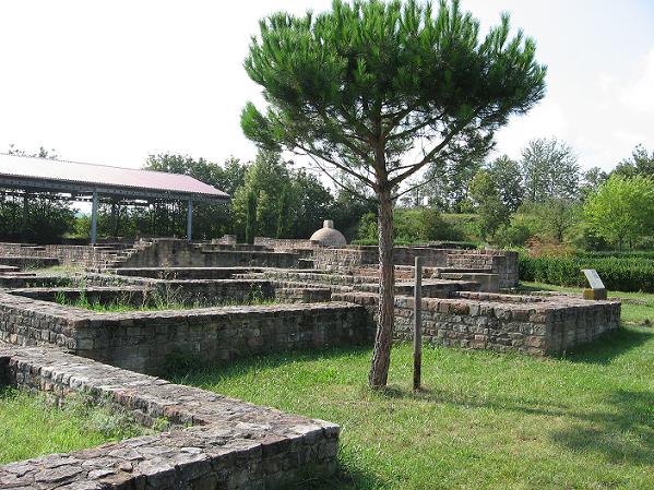
Main building seen from the east wing
(The roofed-in place in the background is a cellar)
The Nemeti were probably a Germanic tribe, though it's difficult to say for sure because of all the tribal moves going on between 50 BC and AD 20. Maybe they were more Germano-Celtic, like the Treveri north of them you may remember from my posts about Trier. A major Roman town in the area was Noviomagus / Civitas Nemetorum, todays Speyer. Read more »
After all the rainy pics of late, I thought I'd share some sunny ones for a change. Here are the first impressions of the villa rustica, the Roman country estate in Wachenheim, a village some twenty minutes drive from Mannheim.
Mannheim lies at the Rhine, so the lands west of the river were Roman-dominated since Caesar who defined the Rhine as border between Gallia and Germania. Finds point to a so-called Elbe-Germanic tribe having migrated in from Bohemia or todays Thuringia (who knows, it could have been some of the guys Arminius conquered when he dealt with the Marcomannic king Maroboduus in 18 AD). They have been connected to the Nemeti known from Roman sources.

(The roofed-in place in the background is a cellar)
The Nemeti were probably a Germanic tribe, though it's difficult to say for sure because of all the tribal moves going on between 50 BC and AD 20. Maybe they were more Germano-Celtic, like the Treveri north of them you may remember from my posts about Trier. A major Roman town in the area was Noviomagus / Civitas Nemetorum, todays Speyer. Read more »
15 Aug 2007
The Saalburg, A Reconstructed Limes Fort
The German Limes was a frontier cutting through the right angle formed by Rhine and Danube, the first borders of Germania. It starts north-east of Wiesbaden and meets the Danube near Regensburg, thus adding not only the Taunus and Odenwald forests but also the fertile lands of the Wetterau and Neckar plains to the Roman Empire. Those areas were called agri decumantes.
The first stage in the development of the Limes was Domitian's victory against the Chatti in 83 AD. To keep them off, a series of watchtowers and forts, connected by a road, were built. The early Saalburg fort (the Roman name is unknown) was a wall and timber fort with wooden buildings housing about hundred men.

Saalburg, wall and trenches outside the fort
The next stage 90 AD was a larger fort, but still a timber construction fortified with walls and trenches. It was flattened when in 135 AD the second Raetian cohors equitata (a 500 man troop of mixed horse and infantry) was stationed in the Saalburg and built a new fort. Read more »
The German Limes was a frontier cutting through the right angle formed by Rhine and Danube, the first borders of Germania. It starts north-east of Wiesbaden and meets the Danube near Regensburg, thus adding not only the Taunus and Odenwald forests but also the fertile lands of the Wetterau and Neckar plains to the Roman Empire. Those areas were called agri decumantes.
The first stage in the development of the Limes was Domitian's victory against the Chatti in 83 AD. To keep them off, a series of watchtowers and forts, connected by a road, were built. The early Saalburg fort (the Roman name is unknown) was a wall and timber fort with wooden buildings housing about hundred men.

The next stage 90 AD was a larger fort, but still a timber construction fortified with walls and trenches. It was flattened when in 135 AD the second Raetian cohors equitata (a 500 man troop of mixed horse and infantry) was stationed in the Saalburg and built a new fort. Read more »
7 Aug 2007
Flavinus, Signifer of the Ala Petriana

Memorial for Flavinius in Hexham Abbey
A signifer is the standard bearer of a cavalry ala (like the aquilifer is for a legion), and an ala is a horse troop of usually 500 men. The Ala Petriana was recruited in Gaul and took its name from its first commander, Titus Pomponius Petra. It was stationed in Corstopitum since 79 AD and some time after 98 AD moved to Uxelodunum (Stanwix near Carlisle). It had then become an ala milliaria of about 1000 men who were awarded Roman citizenship; but that happened after Flavinus' death.Read more »
Flavinius was a cavalry soldier whose grave monument survived, because it ended up in Hexham Abbey, probably during Wilfrid's time. We learn from the inscription below the relief that the slab was erected for one Flavinus, signifer in Candidus' troop of the Ala Petriana. He died age 25, after seven years of service.
A signifer is the standard bearer of a cavalry ala (like the aquilifer is for a legion), and an ala is a horse troop of usually 500 men. The Ala Petriana was recruited in Gaul and took its name from its first commander, Titus Pomponius Petra. It was stationed in Corstopitum since 79 AD and some time after 98 AD moved to Uxelodunum (Stanwix near Carlisle). It had then become an ala milliaria of about 1000 men who were awarded Roman citizenship; but that happened after Flavinus' death.
4 Aug 2007
Hexham Abbey
Besides Roman remains I also visited some Medieaval sites in Northumberland, among them Hexham Abbey. Here as well as in Carlisle Abbey and York Minster, I met with kind, helpful and well informed staff members who took their time to satisfy my curiosity.

Hexham Abbey, seen from the east
The first church on the site dates back to 672. That year Queen Ethelreda (Aethilthryth - how's that for a name, lol) made a grant of land to Wilfrid, Bishop of York. A few years later Wilfrid got on the wrong side of King Ecgfrith, left England for some years and upon his return was imprisoned for a time. It was no easy job being a bishop then, it seems. Read more »
Besides Roman remains I also visited some Medieaval sites in Northumberland, among them Hexham Abbey. Here as well as in Carlisle Abbey and York Minster, I met with kind, helpful and well informed staff members who took their time to satisfy my curiosity.

The first church on the site dates back to 672. That year Queen Ethelreda (Aethilthryth - how's that for a name, lol) made a grant of land to Wilfrid, Bishop of York. A few years later Wilfrid got on the wrong side of King Ecgfrith, left England for some years and upon his return was imprisoned for a time. It was no easy job being a bishop then, it seems. Read more »